

The Peak Tram carried its first passengers on 30 May 1888. It was the first cable funicular in Asia: 1,350 metres of track with five intermediate stations, varnished timber carriages, and coal-fired steam boilers doing the pulling.

The day the Peak Tram opened
The first carriages seated 40 passengers in three classes, with an enclosed centre compartment kept for first class and open slatted benches front and rear. A first-class ride to the Peak cost 30 cents; second class was 20 cents and third class 10 cents, with the return trip at half price. On its first day the tram carried 600 passengers, and about 150,000 in its first year.
Steam gave way to electricity only in 1926. Between 1908 and 1949 the first two seats carried a brass plaque reading "This seat is reserved for His Excellency, the Governor", and nobody could take them until two minutes before departure, in case the Governor appeared unannounced.
Why anyone would build it
By 1883 Hong Kong's population had reached 173,475, while some 30 to 40 families had made the Peak their home. The Peak Hotel had opened in 1873, but getting up the hill still depended on the sedan chair. In May 1881 the Scotsman Alexander Findlay Smith proposed a tram line to connect Murray Barracks with Victoria Gap; approval came in 1882, and the Hong Kong High Level Tramways Company was formed.

Dating a map by its waterfront
The most reliable clue to the date of a Hong Kong Island sheet is where the Central waterfront sits. The shoreline was rebuilt in stages. In 1841 Queen's Road followed the natural coast. In 1856 Governor Bowring proposed a 50-foot-wide promenade some four miles long, reaching east to East Point; it failed, opposed by waterfront owners led by Dent and by a government short of money. The scheme returned in 1866 and met objections from the military; in 1868 the work moved west instead, creating the strip around Bonham Strand, later Des Voeux Road West.
Chater's Praya reclamation was the largest of them: from the gasworks at Sai Ying Pun east to Murray Pier, 10,200 feet long and 250 feet wide, 58.7 acres of new land. Work began in 1889 and finished in 1903, and the new waterfront road is today's Connaught Road.
So the waterfront gives a range rather than a single year. If a sheet shows no sign of Connaught Road at all, it likely predates 1889. If it shows a broad reclaimed strip with Connaught Road running along it, it likely belongs to the 1890s or later, with the later sheets showing more of the finished road. Our 1888 sheet sits just before the first spade went in.
What can be read on the 1888 sheet
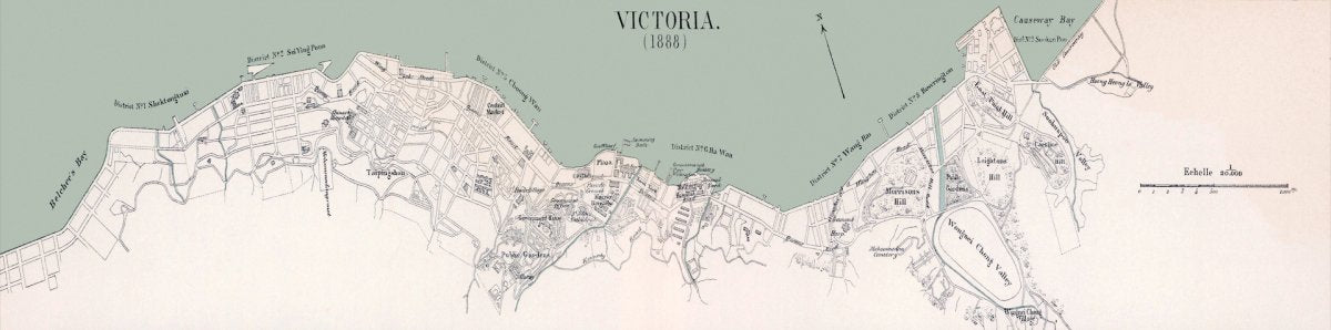
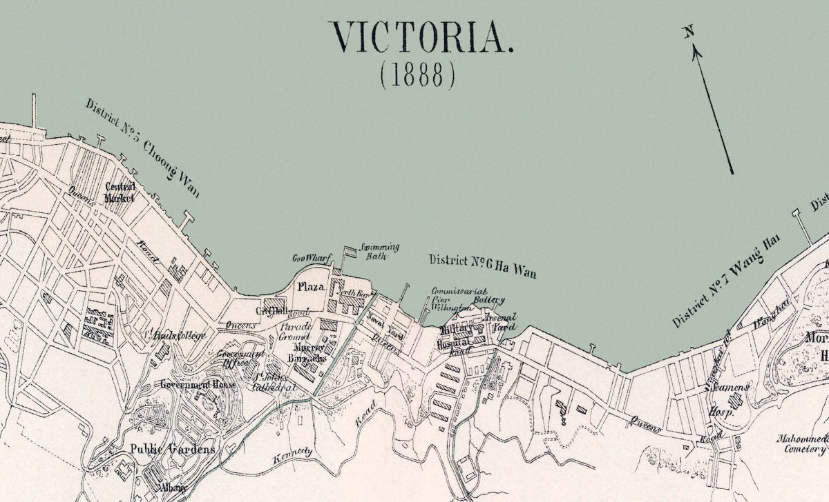
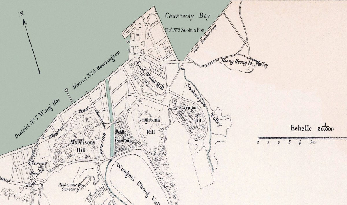
On the restored sheet the engraved names along the north shore are still legible: Central Market, Queen's Road, the Plaza, City Hall, Government House and the Public Gardens, with the Praya marked along the harbour edge. Further east the map carries Causeway Bay, Morrison's Hill, Leighton's Hill, East Point Hill, Caroline Hill, the Old Causeway and Wongnei Chong Valley, which is today's Happy Valley. The shore is divided into numbered districts, No. 6 through No. 9 in the section we can read.
The scale line is in French: Echelle 1/20.000. It is a reminder that these sheets were drawn for a port city where several languages were in daily use.
Check the years yourself with the official aerial photographs
The Lands Department holds aerial photographs from 1924 onwards, and the public can search and view them free through Hong Kong Map Service 2.0, which is the quickest way to follow one street across the decades. The Government Records Service goes further back, with online holdings that include maps, plans and photographs from the nineteenth century. Both are official archives of other sheets and other dates; ours is a restored, print-ready canvas, so the two serve different purposes.
Related maps
Our canvas prints are available in two sizes for the long, narrow sheets, A4 to 50x70 cm for the standard ones, with an optional wooden frame. Hong Kong and overseas shipping, packing and dispatch in about 3 to 14 days. If you want to follow the waterfront after 1888, these three continue the story:
- 1888 Hong Kong Island map on canvas
- 1889 Victoria City map on canvas, the year the Praya reclamation began
- 1909 map of the whole of Hong Kong on canvas
- 1888 map covering the island and Kowloon
Sources
This article draws on the following public sources, together with our own reading of the 1888 sheet (printed place names, districts and scale). Copyright in the sources remains with their authors and institutions. The map images shown are digitally restored versions of the sheets in our own collection, not raw scans. The two historical images are public domain works and are credited above.
- The Peak Tram, official history, thepeak.com.hk (accessed 8 October 2026)
- Hong Kong Memory, "Central Reclamation" (in Chinese), hkmemory.org (accessed 8 October 2026)
- Lands Department, aerial photographs from 1924, landsd.gov.hk (accessed 8 October 2026)
- Hong Kong Map Service 2.0, hkmapservice.gov.hk (accessed 8 October 2026)
- Government Records Service, online holdings, grs.gov.hk (accessed 8 October 2026)
- Wikimedia Commons: "Alfred Prinon - Hafen von Hong Kong (1888)" and "Old peak tram" (both public domain)