

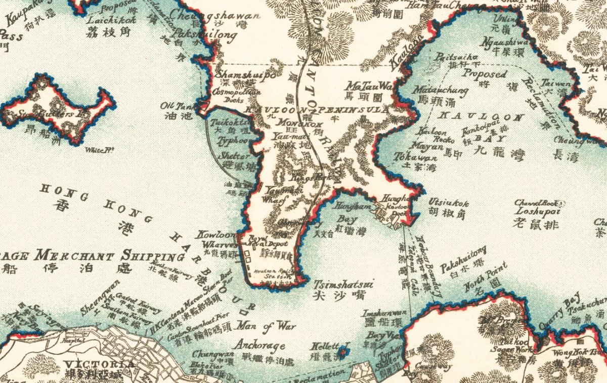
Look closely at the 1924 map of Kowloon Bay and you will find a label that explains the next seventy years of Hong Kong aviation: Proposed Reclamation.
Kai Tak was not built on a drawing board. It was built on mud that had not yet been dredged. The 1924 sheet we reproduce shows Kowloon Bay as open water with reclamation sections marked out — the same water that later became the runway.
What the 1924 map actually shows
- Kowloon Bay — open water, with Proposed Reclamation and numbered sections marked across it.
- Kowloon Docks and Hung Hom Bay — the industrial waterfront that came before the airport.
- Tsim Sha Tsui, Kellett Island and the Man of War anchorage — a harbour still used by ships, not aircraft.
The dates behind the map
- 1912 — Ho Kai and Au Tak form the Kai Tak Investment Company to reclaim land in Kowloon for development.
- 1924 — Harry Abbott opens the Abbott School of Aviation on part of that land.
- 25 January 1925 — Kai Tak opens.
- 1935 — the first control tower and hangar are built.
- 1942 — the Japanese military expands the airfield using Allied prisoner-of-war labour.
- 1958 — the new north-west/south-east runway (13/31) is completed by land reclamation extending into Kowloon Bay; 2,529 m at opening, later 3,390 m.
- 6 July 1998 — Kai Tak closes; Chek Lap Kok takes over.
Sources: Wikipedia, Kai Tak Airport (accessed 24 October 2026), which cites the Kai Tak Investment Company history and the 1958 runway works.
Why a reproduction is the useful object
An original 1924 sheet is a collector's item: fragile, expensive, and usually stored flat and out of sight. A reproduction lets you put the bay on a wall at the size you actually want — and read it.
Ours is printed on canvas in Hong Kong, available unframed or in a solid wood frame, from small sizes up to 80 × 120 cm. Nothing is described as antique: these are high-resolution reproductions of historical maps, clearly labelled as such.
Before you choose a size
The map is landscape, so measure the wall — or the sofa, bed or desk it will hang above — before you pick a size. Our product pages include an interactive size guide that shows the framed print against your furniture at true scale, with live pricing.
See the 1924 Hong Kong & Kowloon map →
Looking for the harbour at a glance rather than street detail? The 1935 map covers the whole territory on one sheet — better for a wide wall, less useful for tracing a single street. For the island's waterfront before the Praya reclamation, see the 1889 Victoria City map.
To see the Kowloon Bay shoreline before reclamation, see the 1900 map of Hong Kong and Kowloon.
Shipping and returns
Ships from Hong Kong in 3–14 days. Damaged in transit? We replace it.